Why We Oppose
There are many concerns and reasons for the community’s opposition to the selection of this Langmaid site for a battery storage facility.
There is a tentative land deal in place between Plus Power and E. Allenspach for the sale of more than 140 acres of which Plus Power intends to develop 12 acres for their battery storage facility. Although we do not know the particulars of this land deal, apart from it being conditional, we can imagine that part of their deal going through will hinge on the IESO awarding a point to the proposal that Plus Power will be submitting December 12, 2023 for the Langmaid Battery Storage Facility.
This makes sharing our concerns with the community, governing bodies and the IESO before December, 2023 imperative.
At any point if you are ready to take action and voice your concerns with us, click the ‘Take Action’ button found at the top of each page and you will find steps you can act on from home.
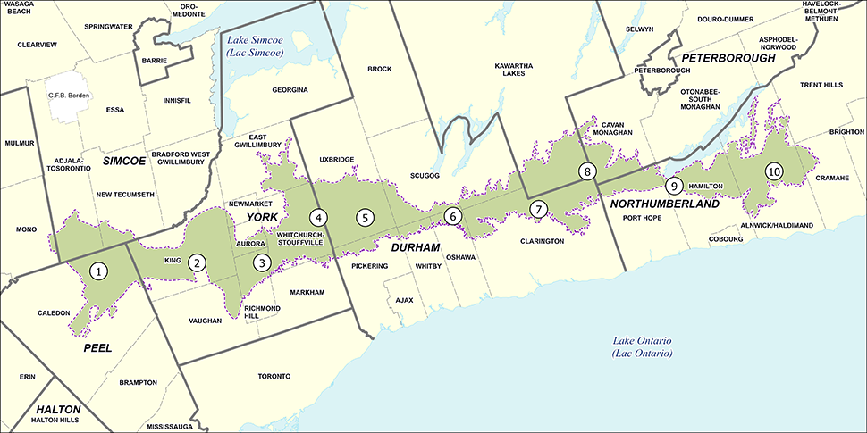
There are more then 30 proposals being submitted to the IESO that we are aware of. There are likely others that we have not been able to locate. To our knowledge, after exhaustive review of other sites, Langmaid Energy Storage is one of only two proposals to propose acquiring land from the Greenbelt.
To view the other locations in reference to the Greenbelt click the Proposal Location Study button.
Why is locating this within the Greenbelt a concern?
This is not the type of “green” the Greenbelt needs. Typically installations like a battery storage facility would be selected to go into an industrial or disturbed areas. Unlike other green energy sectors, such as wind turbines, solar farms or even hydro corridors, which all have minimal footprints and do not sequester land from the natural environment, battery storage facilities are very disruptive.
The newness of Battery Energy Storage Systems (BESS) technology means that it falls into a grey area with zoning. It tries to position itself alongside ‘green technology’ such as wind and solar, yet it’s volatility and material makeup should have it classified as hazardous according to other parliamentary bodies. Current local zoning bylaws have classifications for the disposal sites of batteries, manufacturing and transporting of batteries, but not the operation of systems like this.
The plan set out by Plus Power is to develop (pave over) 12 acres for their equipment, fencing it off and flooding it with lighting for security, rendering 522,000 sq ft of prime, living land, useless to the surrounding ecosystem.
Part of their proposal is that it will generate incomes (1 year of construction jobs, and then a role of 1-3 employees ongoing) for the community as well as an increased tax base for the municipality. The profits, unlike many of the other proposals being submitted to the IESO, we can assume will be leaving the country and not staying to benefit the community. Plus Power is a Texas based company, operating since 2018.
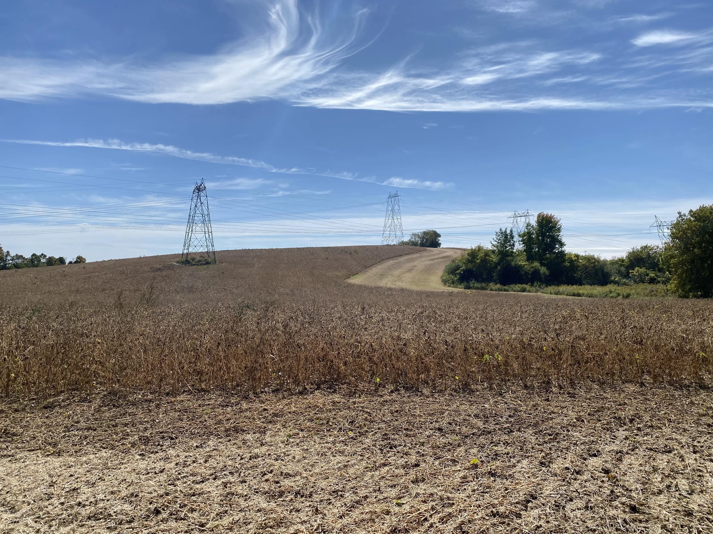
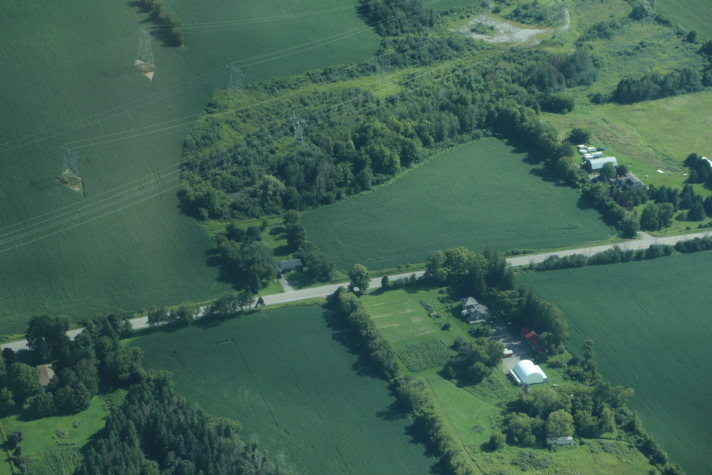
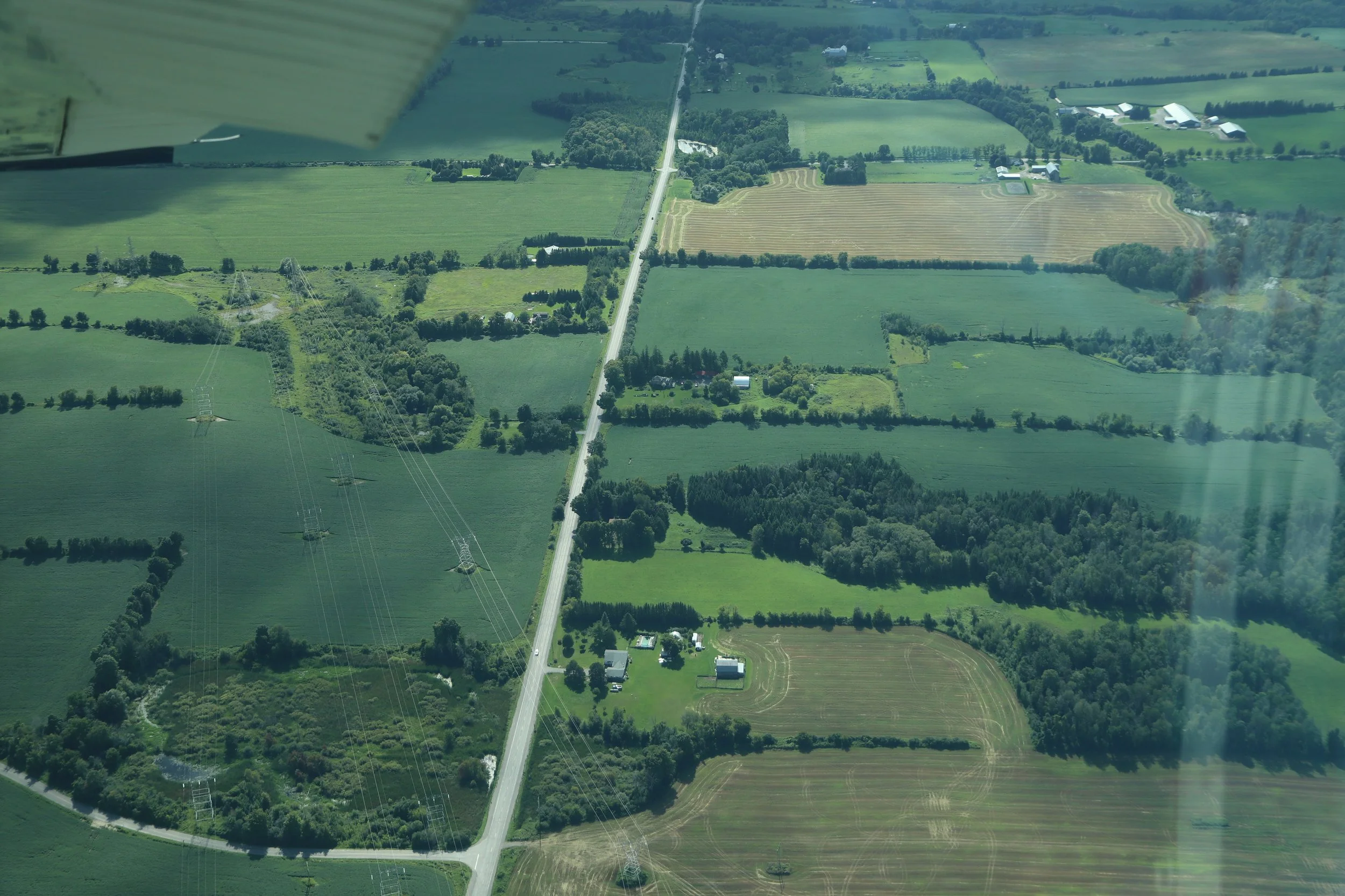
The land is already providing economic value and more in its current state. It is actively farmed and home to a wide range of species. The land filters our water and our air. The origins of Harmony Creek begin here and any disruptions to the ground water will be felt all the way through Oshawa, right down to Lake Ontario.
Research has already been done to show the economic value that land within the Greenbelt provides not only to the local community but well beyond. “In addition to showcasing the Greenbelt’s contributions to regional and provincial economies, this report expands beyond the border of Ontario and links the existence of a healthy Greenbelt in Ontario to strong Canada-wide benefits and significant tax revenues for all levels of government exceeding $2.8 billion every year.“ The economic report can be found here.
Future Cost
Unlike other development, once an installation such as this is installed, the land rarely, if ever is returned to it’s original productive ways. ‘Cheap’ farm land is often grabbed by developers backed by investors whereas many road blocks are often in place preventing the next generation of individuals interested in farming, to begin or continue farming. Once the land is ‘developed’ not only will the price become unattainable for agriculture but the remediation required would be exhaustive.
There are no do-overs.
The proximity of this land to urban areas makes it even more vital to protect as the impacts are felt far due to the proximity to waterways and linking corridors. Durham Regions Official Plan states “It is the policy of Council to: 7.4.9. Consider cross-jurisdictional impacts when reviewing applications for development and site alteration in recognition that the regional natural heritage system is connected to the natural heritage systems of adjacent municipalities.” (pg 167)
Oak Ridges Moraine (ORM)
Zoning within the ORM
“As part of the Greenbelt, the Oak Ridges Moraine is an environmentally sensitive, geological landform in south central Ontario that stretches 160 kilometers from the Trent River in the east to the Niagara Escarpment in the west, covering approximately 470,000 acres.” (Ontario.ca)
Within the Oak Ridges Moraine there are further categorized land use designations such as Natural Core Areas, Natural Linkage Areas, Countryside Areas and Settlement Areas.
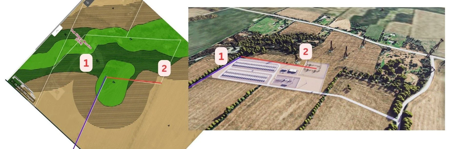
The area within the lots selected by Plus Power for their proposal touches a few differently zoned areas; ORM Agriculture, ORM Natural Linkage Area, and ORM Environmental Protection Zone (Zoning By-Law 2005-109). A pdf of the area with it’s zoning designations can be viewed here.
An interactive map showing these zones can be viewed here.
Why is this location within the ORM a concern?
The Oak Ridges Moraine Conservation Plan (2017) sets out the guidelines for what is allowed within this region. “The vision for the Oak Ridges Moraine is that of “a continuous band of green rolling hills that provides form and structure to south-central Ontario, while protecting the ecological and hydrological features and functions that support the health and wellbeing of the region’s residents and ecosystems.”” (pg 4)
The proposed facility crosses through two natural linkage areas (on both the West and East sides of the lot) in addition to being on Environmentally Protected areas. The remainder covers prime agricultural lands.
“The Oak Ridges Moraine Conservation Act, 2001 establishes the following objectives for the Oak Ridges Moraine Conservation Plan:
(a) protecting the ecological and hydrological integrity of the Oak Ridges Moraine Area;
(b) ensuring that only land and resource uses that maintain, improve or restore the ecological and hydrological functions of the Oak Ridges Moraine Area are permitted;
(c) maintaining, improving or restoring all the elements that contribute to the ecological and hydrological functions of the Oak Ridges Moraine Area, including the quality and quantity of its water and its other resources;
(d) ensuring that the Oak Ridges Moraine Area is maintained as a continuous natural landform and environment for the benefit of present and future generations;”
We have concerns that covering the top of a hill in concrete and gravel, that flows down into known headwaters, will not only impact the local communities water but also those communities South along Harmony Creek. We certainly do not believe that it would improve or maintain the functions of this land.
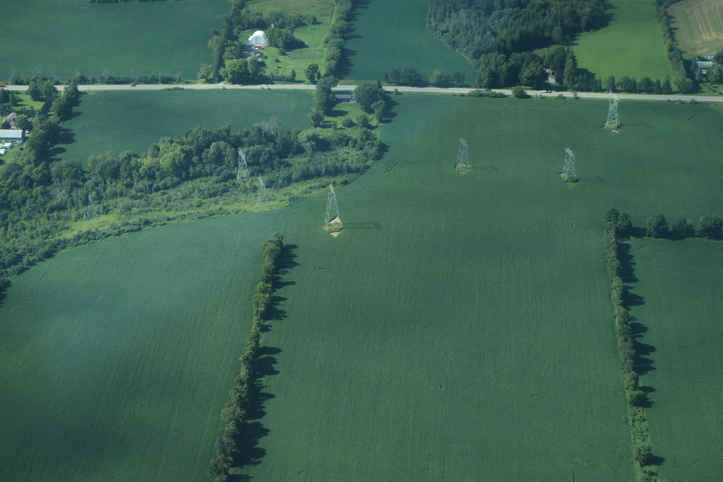
We have concerns that by situating this 12 acre plot in the middle of the larger 140 acre lot, piecemeals it for both human use and a plant/animal biodiversity use. Will birds, bats, insects, mammals be willing to still cross through this area with it’s stark metal boxes and concrete bases, cooling fans humming and lights glowing? Far from a natural landform or environment. There are concerns that this is a ‘gateway’ proposal that would lead to further industrial development on natural areas in this plot of land.
Plus Power said in their community meeting on September 20, 2023 that they intend to leave the remainder of the land as farming for now, yet failed to consider how the land is currently farmed, access points, or the impact of their development on the ability for crops to grow. Many great intentions fall by the wayside without a proper plan in place and as presented, it does not appear that there is a land management plan in place, based on the literature published by Plus Power and minimal engagement at the September 20, 2023 meeting.

Harmony Creek Headwaters
Origins of Harmony Creek
The proposed battery storage lot would drape over the top of a hill. Around the sides and base of this hill are the Environmentally Protected and Natural Linkage areas. These areas are protecting the Harmony Creek Headwaters. From here, water and wildlife travel south to Oshawa Second Marsh before joining Lake Ontario.
Why is protecting Harmony Creek’s Headwaters vital?
We rely on these hydrological features for clean drinking water, flood protection, and healthy ecosystems. Beyond being a natural setting for urban residents to have recreational value in, these water ways, when healthy, are home to a diverse range of species that play important roles in our ecosystem. When suburban residents face issues with flooding, coyotes, rats, or lack the presence of butterflies and songbirds, it is often a result of mismanaged natural areas and waterways.
Simple actions that communities take that seem harmless, already drastically alter our waterways. Not maintaining the municipal ration of landscaped to hardscaped areas on lots leads to less water being absorbed and filtered by the ground. Instead more runs off into stormwater catchment systems and natural waterways where it does not get the opportunity to be filtered. The use of salt on these hardscapes further impacts our waterways and the species that call it home. So much so that in 2012, blue saltwater crabs were found alive and well, surviving in what should have been a freshwater river.
As we can see from other disasters, such as the industrial fire that leeched into Mimico creek and Humber creek on August 11, 2023, containing any ill effects becomes much harder and the effects are more widespread when located near waterways. No sane individual goes into business with intentions of explosions, fires or leakage, but we must be mindful that these events do occur despite best intentions. Keeping these kinds of possibilities far from headwaters is the best form of preventative action.
Even if the proposed facility were to operate without drastic disaster, there are still many water related concerns that the community has.
Vulnerable Aquifers
High Aquifer Vulnerability
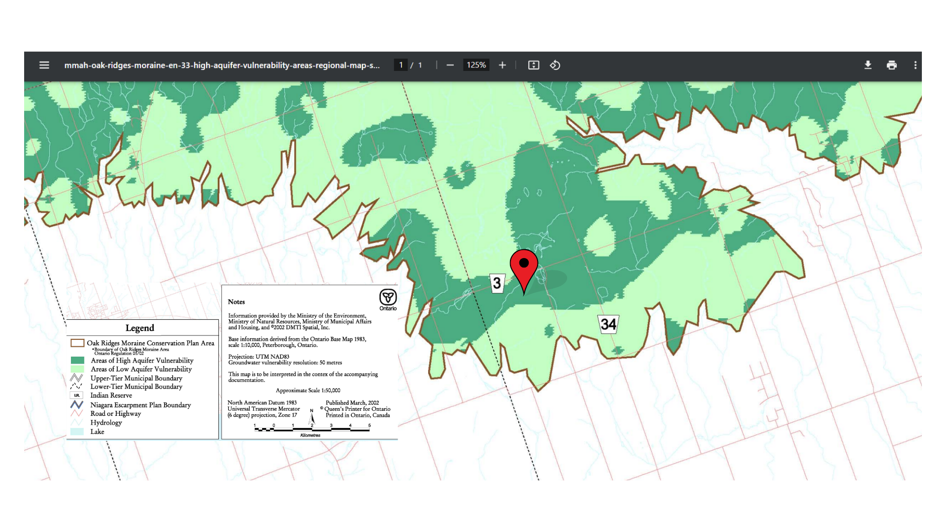
“The objective of the groundwater vulnerability analysis is to identify areas that may be more susceptible to contamination than the surrounding area. These vulnerable areas may be associated with municipal drinking water wells, intakes, or the broader landscape”. The lot selected by Plus Power is situated on an “Area of High Aquifer Vulnerability”.
Is paving over (Plus Power assures us that they will meet the minimum requirements for stormwater management) 12 acres of land to then store and use materials that the remainder of society has to deliver to a hazardous waste facility or store within special rooms, really the best use of land that has high Aquifer Vulnerability?
Canada Land Inventory
The Government of Canada has created a rating system for Soil Capability for Agriculture across our Country. Mineral soils are grouped into 7 classes in this rating system. Classes 1, 2, 3 and 4 are considered capable of sustained use for agriculture. Class 1 are deemed to have no significant limitations to use for crops. These are “Prime Agricultural” land.
What is interesting to note is that some Townships, such as Stone Mills Township, have a requirement “all Green Energy project proposals being submitted to the Township of Stone Mills for endorsement, shall include a report prepared by a qualified professional recognized by the Ontario Institute of Agrologist, that clearly identifies the classification of these lands in accordance with the Canada Land Inventory system. Furthermore, Green Energy projects which include lands that have been classified as, or meet the criteria of Class 1, 2, or 3 of the Canada Land Inventory system, and which are intended to be included as part of a Green Energy project, shall not receive an endorsement by Council.”
Clarington does not appear to have any such measurable standards by which they offer project endorsements, but perhaps they should in order to honour the irreplaceable value that these lands offer to all of Ontario?
The proposed energy storage system by Plus Power falls on Class 1, 4T land. A map of Ontario and its land classifications can be viewed here.
Clarington’s updated Official Plan has not yet been released but Durhams Official Plan, which serves as the baseline for Clarington’s was published in May 2023. Within that document are maps which highlight the various land designations.
We do not have the formal site plan from Plus Power, however we do have their various renderings which showcase landmarks that we used as reference points to be as accurate as we can, with the information available to us. We know that their proposed site plans to encompass 12 acres. The map overlays were made using this available information.
The selection of this lot and it’s location within the Greenbelt and Oak Ridges Moraine, at Harmony Creek’s Headwaters, on prime agricultural land, with a high aquifer vulnerability is our foremost concern.
At the community meeting on September 20, 2023, additional concerns were raised by the community and more have continued to be voiced since. The responses to these questions are supposed to be published on Plus Powers website and included in their RFP to the IESO but at time of publishing, this has not happened.